Environment Health History Land Planning Research Transit

Mapping Flint

Flint, the Vehicle City, birthplace of the General Motors Company and the United Auto Workers, a vanishing city propelled to the spotlight by one of the largest municipal public health crises in the 21st Century, the Flint Water Crisis

  • Mapping Flint: Flint River Watersheds

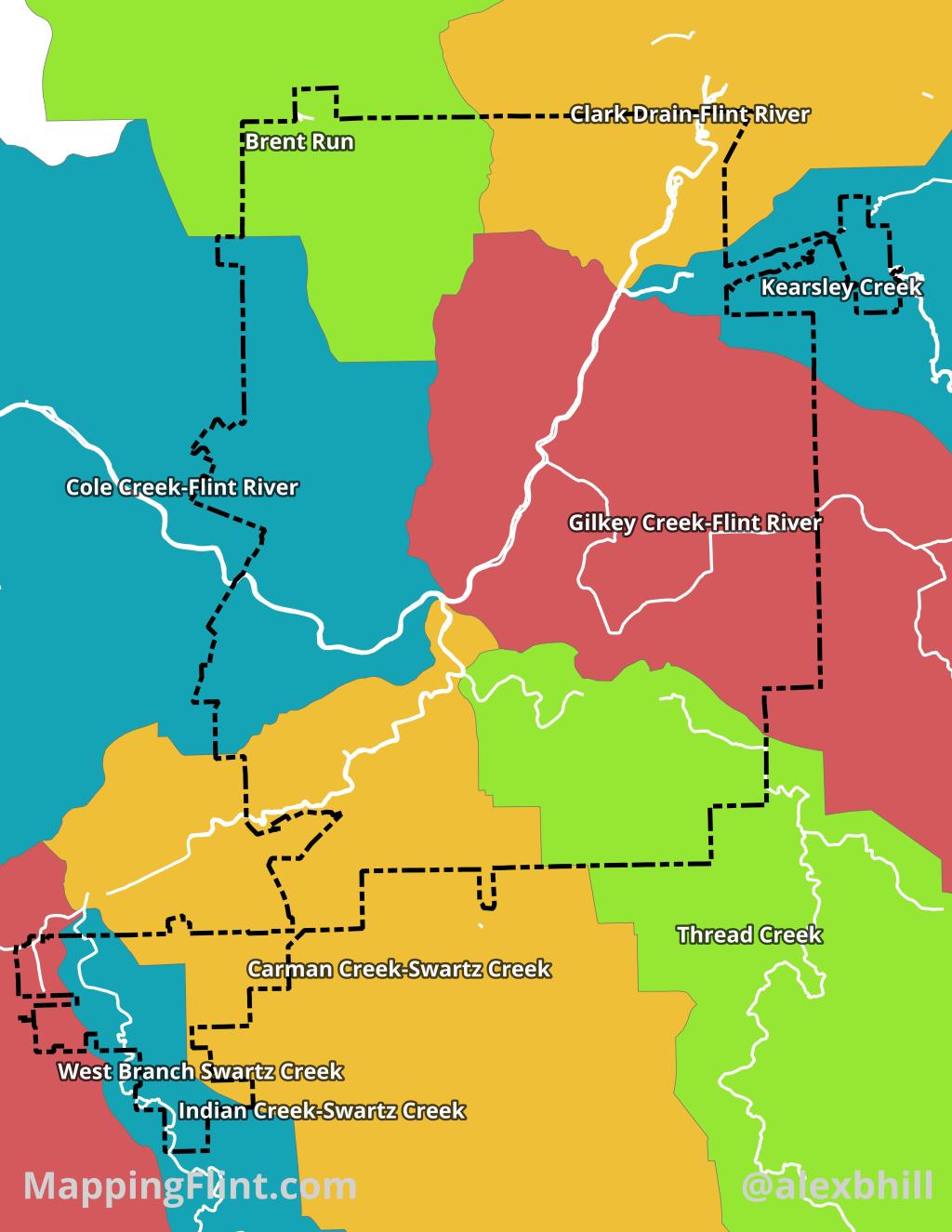
    The Flint River Watershed is a vital, 1,363-square-mile drainage basin across seven southeastern Michigan counties, ultimately feeding into the Saginaw Bay and Lake Huron. Originating in Columbiaville, the river flows northwest through diverse landscapes, including agriculture, forests, and the urban center of Flint.

    Historically central to regional development and mill power, the watershed now faces significant environmental stress from industrialization and urban runoff. Persistent issues such as nutrient runoff, bacterial contamination, and legacy pollutants threaten aquatic life and recreational use, making cleanup essential for the region’s ecological and economic health.

    Numerous organizations are actively dedicated to the conservation and restoration of the Flint River Watershed. Leading the local charge is the Flint River Watershed Coalition (FRWC), a non-profit group that focuses on monitoring water quality, restoring natural habitats, and educating the public. The Michigan Department of Environment, Great Lakes, and Energy (EGLE) provides regulatory oversight, funding, and technical assistance. This multi-faceted, collaborative approach is essential for addressing contamination.

    Larger regional and national organizations, such as the Saginaw Bay Watershed Initiative Network (WIN), support the health of the Flint River by addressing broader ecosystem connections and non-point source pollution. Various environmental groups and universities also contribute by conducting research on pollution sources, developing innovative restoration techniques, and advocating for stronger environmental policies.

    This network of dedicated organizations is crucial to the ongoing work of protecting, restoring, and ensuring the long-term vitality of the Flint River and its surrounding lands.

    Produced for Flintside
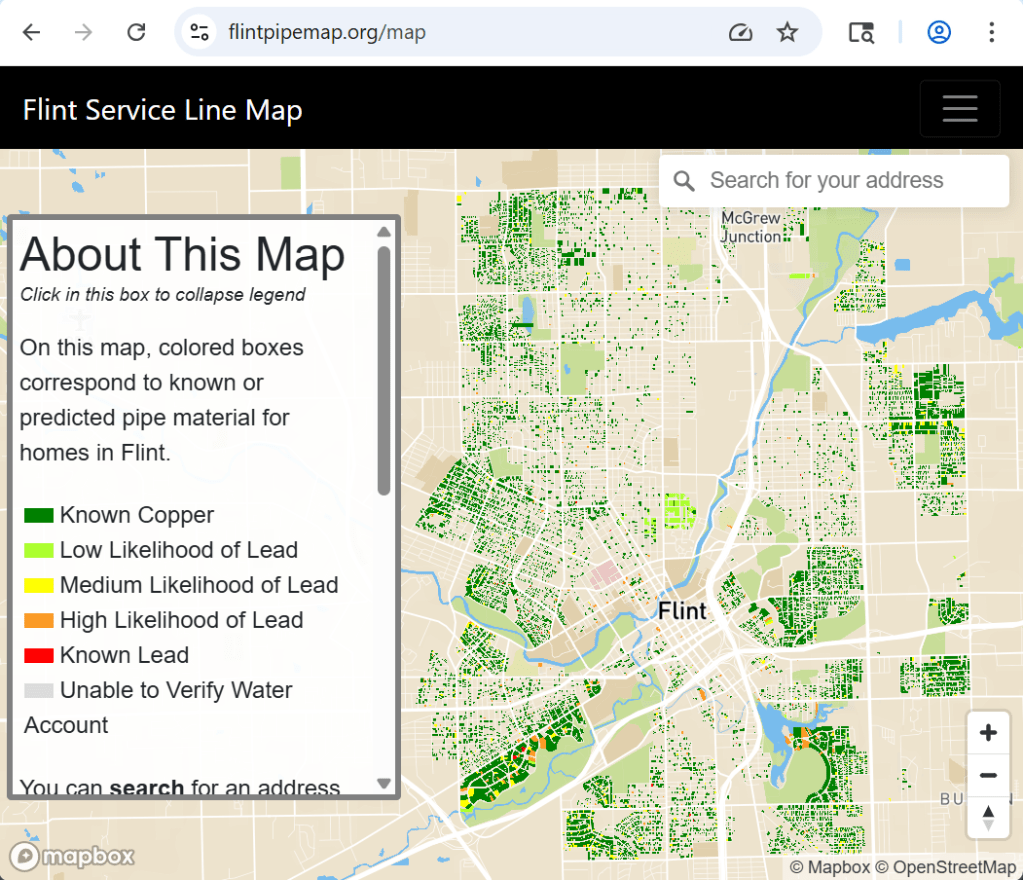
  • Flint Pipe Map: Mapping Water Service Lines 2022

    The “Flint Pipe Map” was created in October 2020 and last updated in June 2022. The map is based off of a mathematical model that predicts water service line material based on multiple factors like building age, existing water line inspection data, and other factors.

    More from the FAQ:

    This map provides information about the known or likely material of the water service lines at different addresses in Flint, Michigan. It is intended to share up-to-date water service line information with the citizens of Flint. The map includes information gathered by the City of Flint during water line inspections and/or replacements. At residential addresses where the City has not yet inspected the water service lines, the map indicates the likelihood of lead or galvanized steel service lines based on mathematical modeling by Dr. Jacob Abernethy and Dr. Eric Schwartz. The map website was built and is maintained by Jared Webb. Dr. Stacy Woods of the Natural Resources Defense Council collaborated on the map and site design.

    Dr. Jacob Abernethy and Dr. Eric Schwartz and their affiliates do not guarantee the accuracy of the information contained in the Flint Water Service Line Materials Map or otherwise represent that the map is accurate. The Flint Water Service Line Materials Map shall be used for the sole purpose of providing Flint residents with the best available data regarding their water service lines, and not for any commercial, legal, or other use. Dr. Jacob Abernethy and Dr. Eric Schwartz reserve the right to alter, amend, or terminate at any time the display of the Flint Water Service Line Materials Map.

  • Mapping Flint: Vacant Land

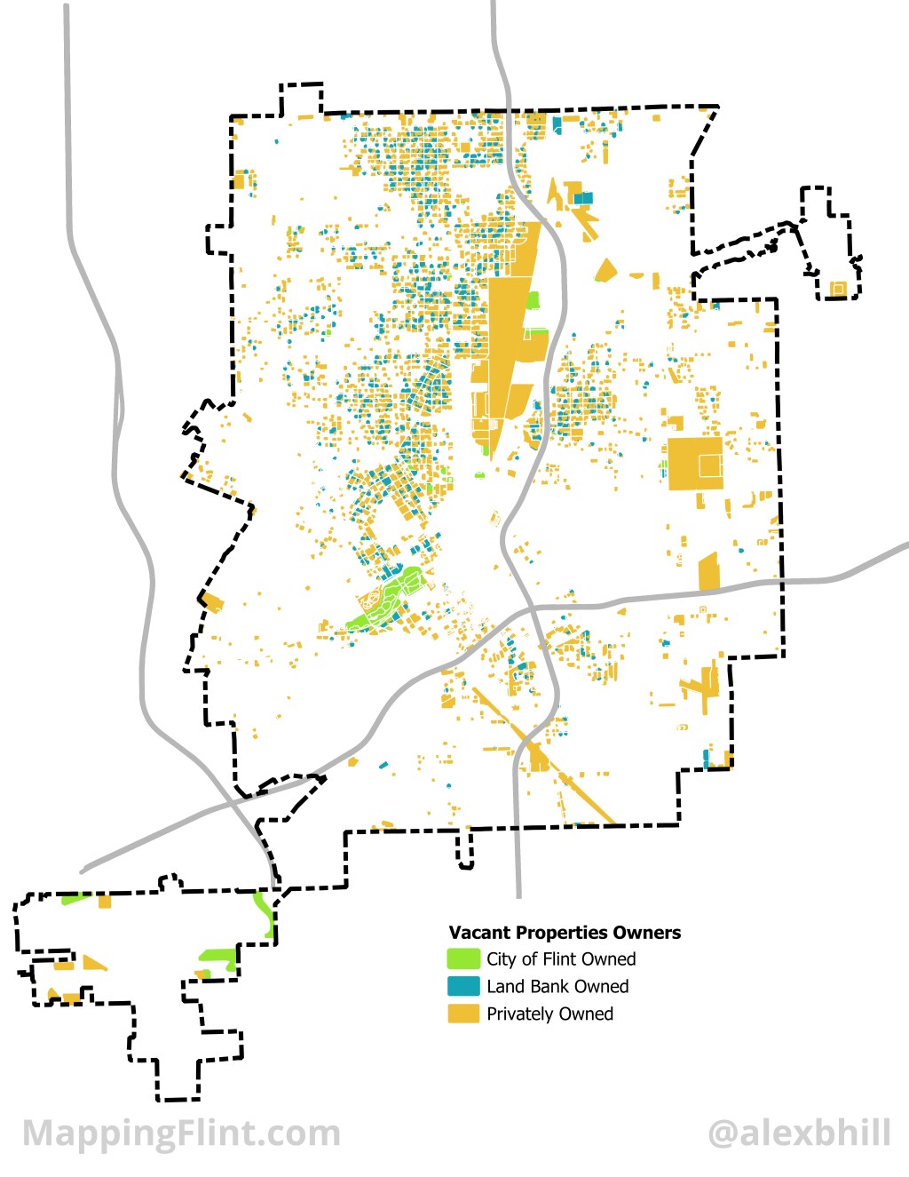
    Flint is home to “The” Land Bank, or at least the first modern implementation of a public authority tasked with managing vacant properties. Today there are 353 land banks at the city, county, or state level. Most land banks take advantage of state level laws that enable them to exist and in Michigan that law was passed in 2004. In Michigan, a new interpretation of brownfields, or any property that has been developed, opened the door for innovation in managing vacant and abandoned properties to bring them back to productive use for cities. 

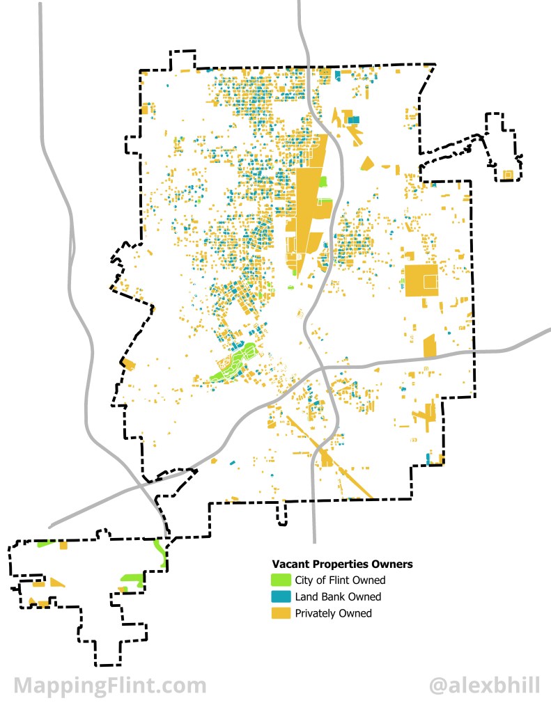
    The Genesee County Land Bank Authority (GCLBA) has tracked its work since 2004 and boasts over 9,000 structures, sales of over 10,000 vacant lots, and 5,000 lots back to community uses. The GCLBA has taken control over over 14,000 properties in its time, but still has an inventory of 13,626 properties. The GCLBA’s property inventory is 80% vacant land. Across the City of Flint there are over 17,000 vacant lots and not all of them are publicly owned or managed by the GCLBA. 

    The distribution of ownership across vacant land in Flint shows how difficult it can be to manage land in a city experiencing economic stress. The majority of GCLBA vacant land is residential while most of the privately held vacant land is commercial and industrial.

    Produced for Flintside

  • Map: North Flint defined by Mott Foundation

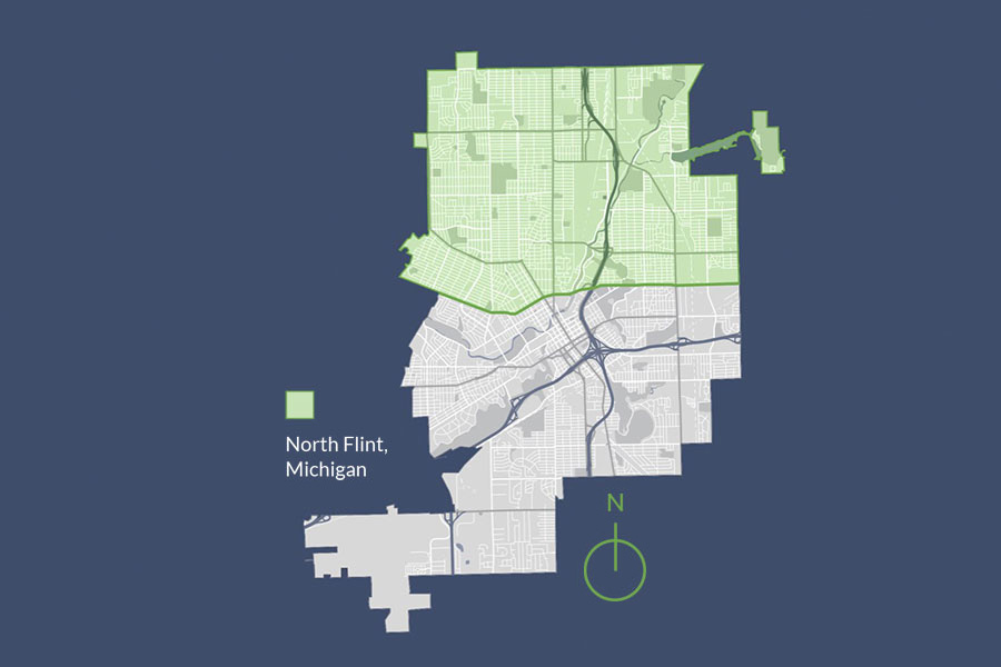
    What cardinal direction matters most in Flint? The Mott Foundation is focused on North Flint:

    “We define north Flint as everything within the city limits north of the Flushing Road/5th Avenue/Longway Boulevard corridor.”

  • Map: Crapo Island on the Flint Sanborn Map 1886

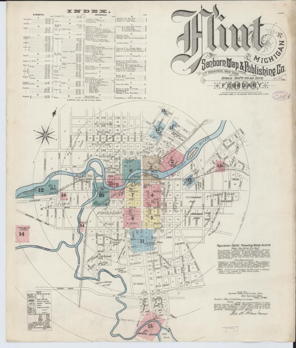
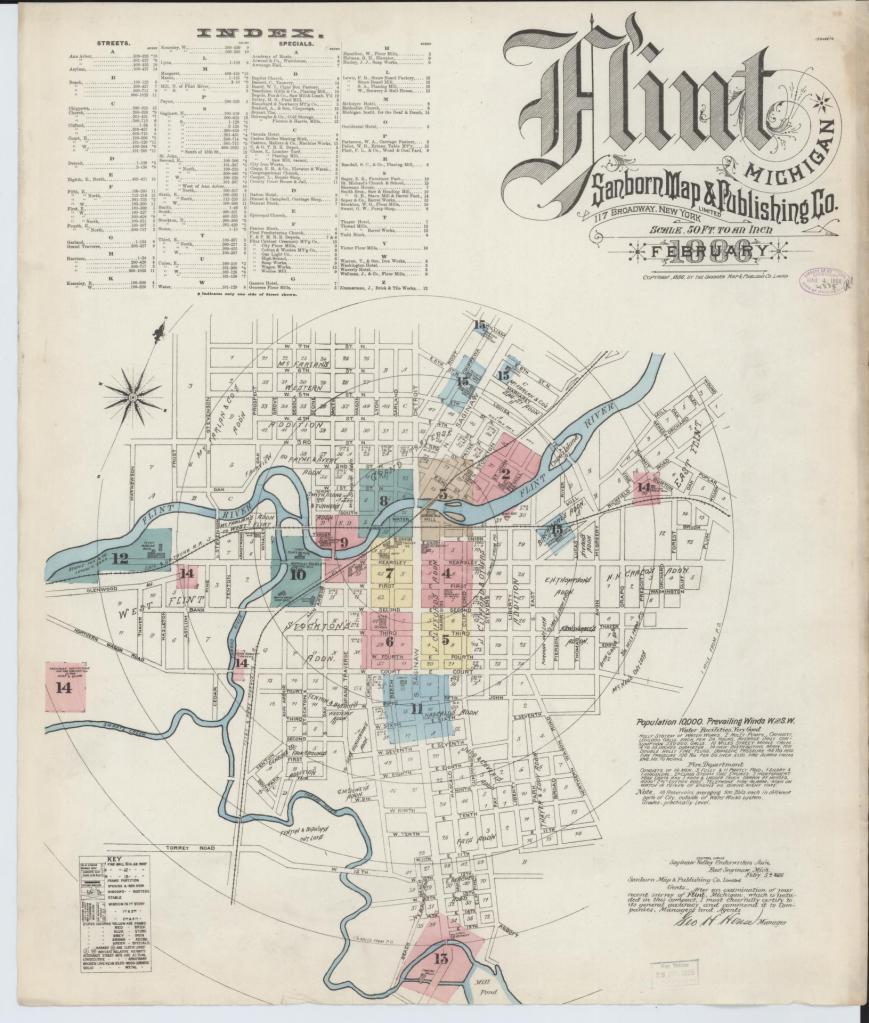
    Sanborn maps are a useful historical tool and often reveal interesting pieces of the past that are long forgotten. On this fire insurance map in particular I was surprised to see such a sizable island in the Flint River, Crapo Island.

    Named for Henry Crapo, the UM Flint Genesee Historical Collections Center notes the Crapo family to be the biggest impact on Flint. Crapo moved to Flint in the 1850s and had a very successful lumber business. He was elected mayor of Flint in 1860 and then Governor of Michigan for two terms from 1864 to 1869 before retiring. William Crapo Durant, founder of General Motors, is the grandson of Henry and Mary Ann Crapo.

    Now the oddity of Crapo Island appears to be long gone, but I can’t find any reference to when it was removed from the river. In 1907, William Crapo, Henry’s oldest son, presented the island as “Crapo Island Park” to the City of Flint. In 1929, the east channel of the river filled in and Crapo Island became the east riverbank. In 1940, the Flint City Market was built on land that had been part of Crapo Island and the old river channel.

    You can still see how the riverbank bumps out under the 5th Avenue bridge.

  • Mapping Flint: Understanding Flint Geography

    Flint, to me, has always been about family and cars. 

    My great grandfather worked for Chevrolet in what became better known as “Chevy in the hole.” My grandfather worked at the Flint Assembly Plant and was an active member of the UAW. My grandmother’s family opened the first Chrysler dealership in the Flint area in 1926 before running the Oldsmobile dealership.

    Both of my parents grew up in Flint with stories of attending community schools, watching the spark plug parades, and ice skating at Atwood Stadium. Actually five members of my immediate family were born at St. Joe’s hospital which closed in 1997. My dad bought his first home on the Bradley Avenue hills of Crim notoriety. 

    My childhood was spent visiting the Cultural Center of the city, taking trips to the Flint Institute of Arts, Longway Planetarium, or the Flint Public Library, learning to swim at Hurley Health and Fitness, running the Crim, and taking classes at Mott Community College. I attended Powers Catholic when it was located in the North End and often volunteered with the St. Luke Center. Most of my family lived in areas of South End near Miller Road, Thread Lake, and Bristol Road.

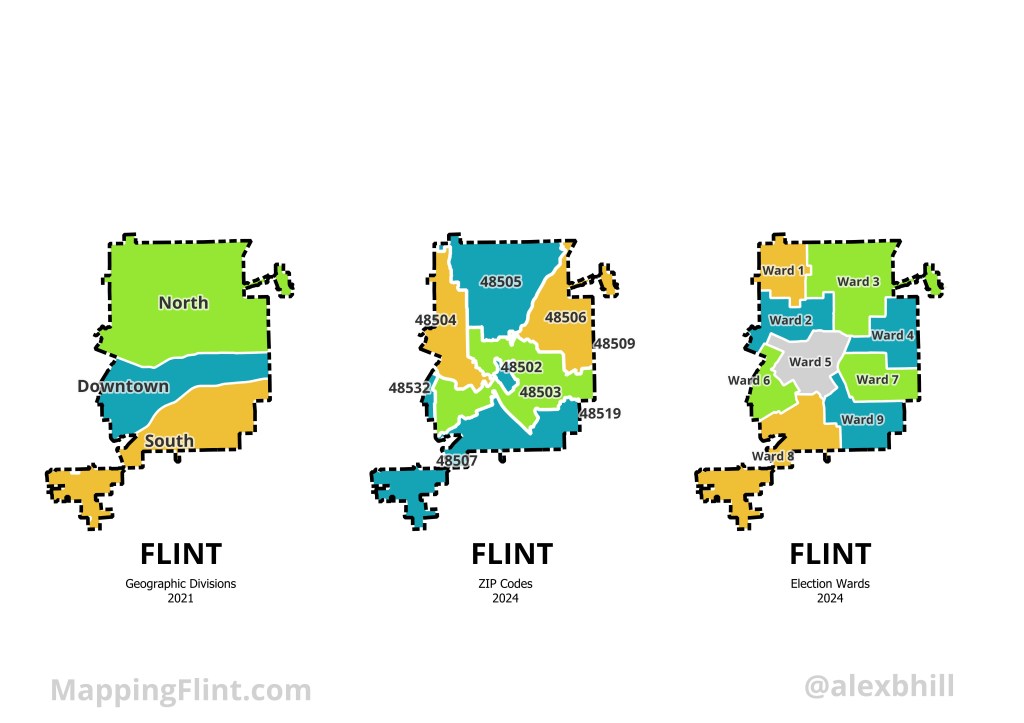
    Thinking about all the Flint places important to my own story I tried to come up with a way to quickly reference the geography of the city. North, Downtown, and South area helpful geographic divisions. Specific ZIP codes are easy to know from family and business addresses. How do you represent Flint? What are the ways that you reference where you are in the city?

    Produced for Flintside

  • Map: Flint River Indian Reservations 1879

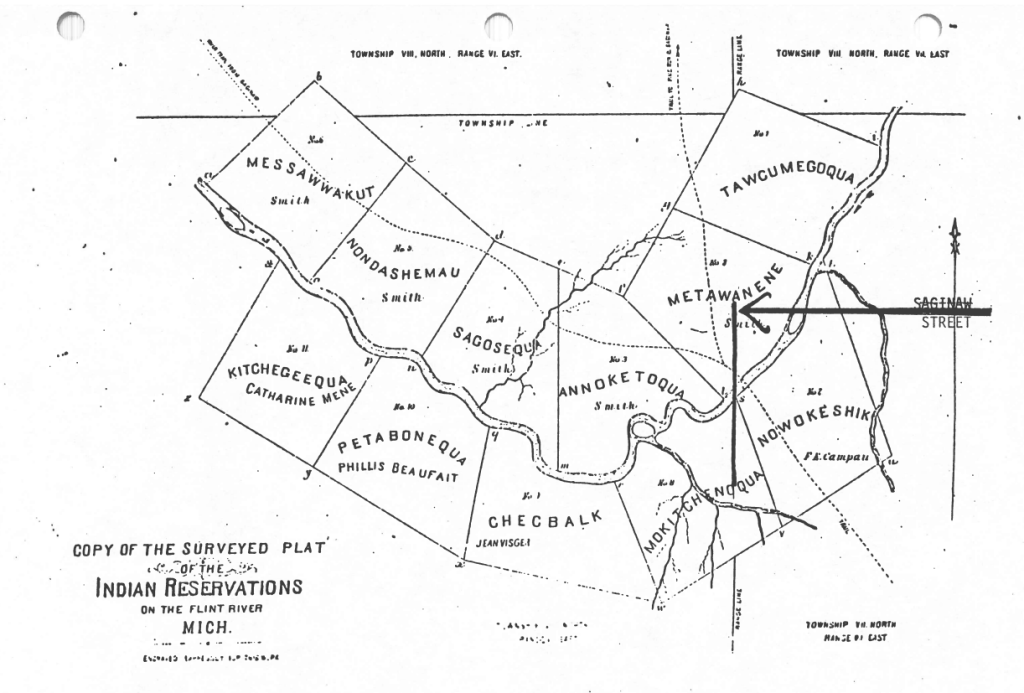
    Flint’s history is that it was a collection of 11 Indian Reservations along the Saginaw Trail next to the Flint River called Grand Traverse Village. Present day Saginaw Street is the bold line noted by the arrow on the map.

    Indigenous burial mounds were documented along the Flint River in the 1830s and archaeological digs in 1899 noted the presence of historic indigenous villages. The names of these villages became enshrined in the Saginaw Treaty of 1819 that established 11 reservations along the Flint River under Governor Lewis Cass. The reservations constituted 7,041 acres of land along the south bend of the river.

  • Map: Imagine Flint Master Planning 2013

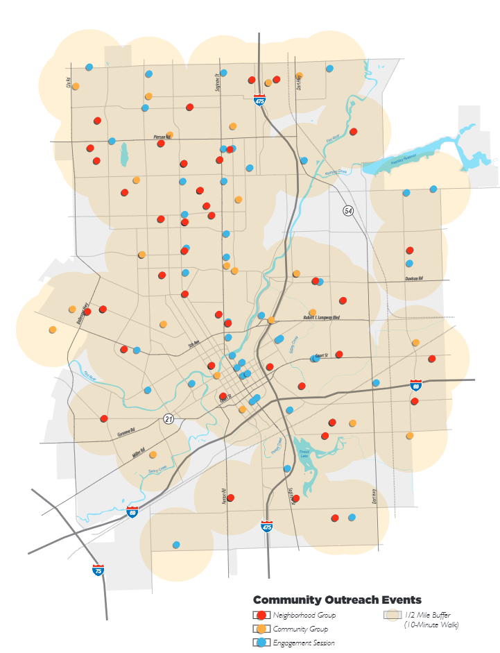
    Flint embarked on an ambitious master planning process when it didn’t even have a planning department in 2013. This was the city’s first master plan since 1960. The “Imagine Flint” effort engaged over 500 residents through 280 engagement sessions and hosted community events.

    Flint is currently in another master plan update process for 2024-2025. The plan update was expected to take 18 months, but it’s unclear from the City of Flint website what meetings or opportunities are happening into 2026.

  • Map: Elevated Lead Levels by Flint Wards 2015

    This map from National Geographic was published with the article: “Five years on, the Flint Water Crisis is nowhere near over.” Much of the water testing in Flint showed elevated lead levels remained high into 2015. The downtown band with Wards 5, 6, and 7 showed the highest levels.

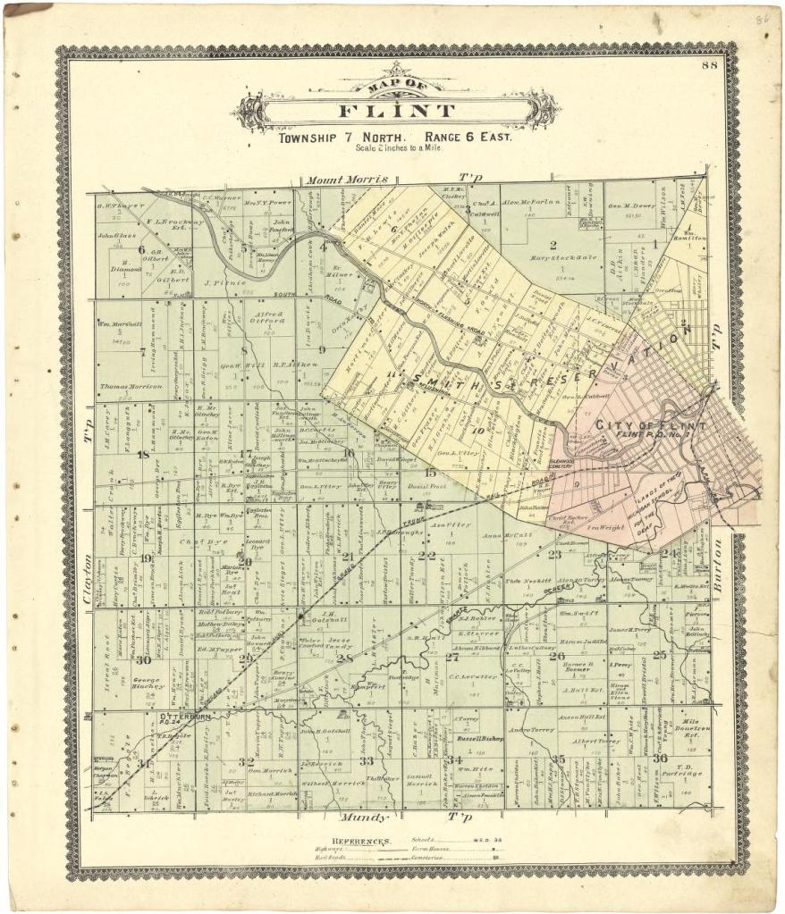
  • Map of Flint 1889

    This historical gem from the Library of Congress comes from the “Atlas of Genesee County, Michigan” shows the City of Flint as a much smaller entity than present day with remnants of the Smith’s Indian Reservation that eventually became part of Flint proper. I was surprised to see that Michigan School for the Deaf has held their land as far back as this, but then checked that the school was founded in 1848 and opened in 1854.